23 July 2006 Sunday

Horrible night!  In the middle of the night, we woke up with mosquitoes in the truck.  LOTS of mosquitoes!  We thought about what we could do, including finding a hotel (at 2am, outside the park, not a good option).  We decided to turn out fan around and blow air from the back of the truck into the cab.  The bugs were then sucked out of our sleeping area and we finally got back to sleep.  This morning we both felt like crap.  

We have a tough hike planned and we want to get an early start before it gets too hot.  I don’t’ know how, but there are still several patches of snow on the ground, even though it’s in the 90’s during the day.  The highest elevations are cooler, but the lower elevations are hot and buggy.  

We hiked up Mt Scott, the highest peak in the park.  In 2 1/2 miles the trail climbed 1,500 feet.  It was a tough hike, but the views were worth it.  Along the trail and at the top, we had the most incredible views of Crater Lake, along with Mt Shasta, Diamond Peak and Diamond Lake, among others.  We were the first ones on the trail, but one woman passed us near the top.  As we were heading down, we saw lots of people on the way up.  It’s getting hot and we’re really glad we started early!  

We started to drive the Rim Drive around Crater Lake, checking out some of the overlooks and features.  We stopped at an overlook for the Phantom Ship.  The Phantom Ship is rock structure that looks like a ship with sails.  The rock that forms it is far older than Mt Mazama, the mountain we’re standing on now.  This ancient volcanic rock cinder cone had been engulfed by Mt Mazama, but later erosion exposed it within the lake. 

We stopped at another overlook for the Pinnacles.  This is a creek whose volcanic ash canyon walls have been eroded into strange pinnacle formations.  The formations were somewhat like those we saw at Bryce Canyon, but these were all gray in color.

It was at this overlook that we realized that our left front tire was very low.  Andrew pulled out our air compressor and aired up the tire, blowing a fuse in the “Tower of Power” in the process.  We found out we had picked up a nail from somewhere and needed it fixed.  We were a little concerned about how quickly our tire had been leaking, so we went out of the park to find a place to have a tire plugged.  Trying to find a service station to fix a tire in small town America on a Sunday afternoon is impossible!  We went to the first small town outside of Crater Lake and found only a few cows idly grazing, unconcerned with our plight.  

We moved on to the next town, about an hour away, Klamath, OR and didn’t find much there either.  We are now an hour outside of Crater Lake and considering going another two hours to get to a town to get our tire fixed.  This would put us three hours from Crater Lake but within thirty minutes of our next destination.  So, we didn’t get to finish our Rim Drive and we didn’t get the boat tour of Crater Lake.  

The temperature is over 100 degrees and we’d had a miserable night last night because of the heat and bugs.  So we started looking for a hotel with air conditioning in Grant’s Pass, OR. The first hotel we looked at had lost power that day and most of their rooms were very hot.   The Sunset Inn is a very nice place with a wonderful AC system!  As we were gettig our things out of the truck to go into the hotel, I grabbed a bottle of wine that we’ll open after dinner.   Andrew took it and put it with some other things and came back for something.  I heard the sickening POP of a full wine bottle hitting pavement.  And it wasn’t a bottle of Two Buck Chuck that hit the ground!   No, of course not!  This was a more expensive bottle we picked up on sale for $5.00 before we visited Napa.  Drat!  We’ll never know if it was a good wine.

There was a Chinese restaurant next door to the hotel and we ate there.  Our waitress was quite theatrical!  When we mentioned we were from Georgia, she said: “Well, Fiddle dee dee! Gone With The Wind was my favorite movie ever!”  And then she went on about the dresses and the hoop skirts.  We assured her that things have changed a bit since then.  

Later, back at the hotel, we got more photos uploaded with the help of the high speed Wi-Fi connection. 

Posted in Teresa's "Not-So-Daily" Diary | Comments Off on 23 July 2006 Sunday

22 July 2006 Saturday

We took a scenic drive along the UmpquaRiver.  It is a really beautiful river in a deep canyon.  Thisarea is very lush and rainforest-like, similar to North Carolina.  Steephillsides covered in thick forests and ferns.  This is a big fishing area,we saw lots of fishermen out along the banks of the river.  It rained thismorning along our drive and a thick fog hung over the river.  Verydifferent from the deserts in the Southwest.

We got into Crater Lake and begandriving up and up.  Crater Lake is actually a caldera. The volcano MtMazama may have been over 14,000 feet high at one time, but the volcano wasvery active and had several side vents.  When these side vents opened up,drained the magma (lava) out and the whole top of the mountain collapsed. The resulting caldera filled with rain and snowmelt.  Crater lake has noother water source, no streams flow into it and no streams flow out of it, onlysnowmelt and rain. The water is very deep, very blue, very pure.  And very beautiful.

There are a few other features within the lake.  Wizard Island is kindof a volcano within a volcano, within the lake.  It’s a cinder cone thatbegan rising and became dormant.  It’s now covered with trees andfoliage.  Another feature within the lake is the Phantom Ship.  ThePhantom Ship blends into the surrounding steep caldera walls at many angles, disappearinglike a phantom.  They offer a boat tour to get to these features that we’regoing to check out later.

We got info on the park and made our plans for the next couple of days. We hiked Annie Creek Canyon.  We had trouble finding the trailheadinitially, it starts in the campground.  We aren’t staying at thecampground.  We started hiking down into the canyon and swatting hundredsof mosquitoes.  As we hiked down into the canyon, we saw the beautifullittle creek, Annie Creek, and it’s wet, marshy shores.  Prime breeding’skeeter breedin’ areas.  We were hiking fast and swatting skeeters evenfaster!   I stopped to take a photo on occasion and feel like I lostblood each time.  We finally survived the 1.7 mile loop hike, but weprobably gave up a pint of blood each.  

We got back to Mazama Village where we parked and bought a couple of showers,75 cents for four minutes of water.  We drove just outside the park andfound a road on National Forest land (Your Public Land) and camped out for thenight.

Posted in Teresa's "Not-So-Daily" Diary | Comments Off on 22 July 2006 Saturday

21 July 2006 Friday

We started off with a breakfast of fresh chicken eggs and bacon Marthaprovided.  Chris had to leave early this morning.  He’s on a scheduleand meeting others down the road.  Andrew and I stayed around to helpMartha with the chickens and rabbits.

We are closing on our land today.  Around 10:10am we got a call from ourrealtor.  The closing went off without any problems and we are now the newowners of a lot in Spruce Basin, Cotopaxi, Colorado!

It’s hot here, over 100 degrees, but in the shade it doesn’t feel sobad.  The air is much drier here than in the east.  When it cooled offa little, we took off and headed south towards Crater Lake.  We found aforest service road along the way for the night.

Posted in Teresa's "Not-So-Daily" Diary | Comments Off on 21 July 2006 Friday

20 July 2006 Thursday

We’re on the road again, heading north into Oregon.  We made it toLebanon, OR and met Chris on his friend Martha’s 50 acre ranch.  She hasseveral rhea(a small ostrich), sheep, rabbits and chickens.  And two kids.  Shehas her hands full.  She purchased this ranch as an established ranch witha few other people, but things didn’t work out.  She is now running thingswith her two kids, Kyle and Keegan, and her friend Leslie.  The place hasgreat potential!  Martha told us of an elderly lady who dubbed her the"Duchess of Neverdone", so we were jokingly referred to her ranch asthe Neverdone Ranch.

When we got there, we began a tour of the place, but Martha had to run intotown for errands, so Chris continued the tour.  We took the ATV out tocheck out the large grass field and wooded acreage that’s all part of theproperty.  Chris is having way too much fun on the ATV.  All three ofus on the ATV was slowing it down quite a bit.  We noticed the warning labelsto always wear helmets (we didn’t) and to never carry passengers (well, therewere three of us).  The grass is about 5 feet high, hiding all the bumpsand holes.  Fun ride!  We were all covered in grass seedsafterwards.  

Andrew, Chris and I opened up a bottle of Two-Buck Chuck and Leslie came outto join us.  Martha was still out running errands, but she doesn’tdrink.  When she did come in, we offered her a lovely cranberry juice,vintage Tuesday.

Posted in Teresa's "Not-So-Daily" Diary | Comments Off on 20 July 2006 Thursday

19 July 2006 Wednesday

We did a little grocery shopping in Mt Shasta, CA and then found a libraryfor some air conditioned computer work.  We stayed there for much of theday.  The library had a huge book sale going on and although our space islimited, we picked up a few books for reading on the trip.  

We had planned to hike around Mt Shasta along the Pacific Coast Trail, butour plans have changed.  Our friend Chris, formerly from San Francisco, butnow a fellow nomad (or TECH-nomad) is visiting with friends a few hours north ofhere.  Tomorrow we’ll head north to met up with him.

We found a better campsite in the National Forest for the night.

Posted in Teresa's "Not-So-Daily" Diary | Comments Off on 19 July 2006 Wednesday

18 July 2006 Tuesday

We started off the day with another wine tasting at 10am.  Please note: TASTING wine, not DRINKING wine.  (Our Napa experience has shown us we’re clearly not alcoholics.)  We started off with a free tasting at the Frank Family Vineyard, another suggestion from Ricardo.  This winery also had sparkling wines.  The tasting experience was somewhere in between yesterday’s tasting and so were the wines.  They had a showroom tasting bar, but it was a bit less rigid and scripted than Beringer’s.  The wines were good, better than Beringer’s by far, but still not up with Conn Valley.

Our next stop was Chateau Montelena.  This is a beautiful estate with an interesting history.  It was initially established as a winery, but during Prohibition, it move into orchards and farming.  In the 1950’s it was owned by an Oriental couple who didn’t care about farming, but created a beautiful lake and gardens.  In the 1980’s, it was under new ownership and turned back into a winery with a beautiful lake and gardens.  We split a $10.00 tasting of 5 wines.  When I first saw tree white wines on the list of five, I thought “Ugh, we really don’t care much for white wines”, but these were not the typical white wines we’ve had before.  The Riesling was tasty and clean and the two Chardonnays were crisp and fruity, not the heavy, buttery Chardonnays I’ve had before.  We also sampled two Cabernet Sauvignons which were wonderful.  These wines came closer to the quality of Conn Valley’s wines.  After the tasting, we walked around the beautiful Jade Lake and fed the swan, ducks, turtles and fish.  

It’s lunchtime and Ricardo recommended Taylor’s Refresher.  This place is a walk up/ outdoor dining type of place with good gourmet food.  We both had tacos, I had fish tacos and Andrew had the shrimp tacos.  Both were wonderful, but a little pricey for outdoor dining. 

Today’s not as hot as yesterday, but it’s still quite warm.  It’s time to head north, out of Napa Valley and towards Mt Shasta.  The weather is still quite hot, in the 90’s, in Mt Shasta.  We found a campsite for the night, not great, but it will do for tonight.

Posted in Teresa's "Not-So-Daily" Diary | Comments Off on 18 July 2006 Tuesday

17 July 2006 Monday

We’ve got a lot to do today.  We have to find a place to mail our property papers, among other things.  Our first stop was laundry and then shipping.  We found a place to print out some things and got all our errands done by lunchtime.  We found a brewery for lunch.  The Silverado Brewery and Restaurant.  Of course, we would go to a brewery in the heart of wine country!  They have a saying here, “It takes a lot of great beer to make a good wine”.  It seems that’s referring to the vineyard workers drink beer after a day in the fields.  Considering the beer we found, I think they all drink Budweiser.  We did find any great beers here, in our opinion.  The food was good, but the beer was a bit weak.  

We got our errands done, we’ve had lunch, now it’s time to find a winery tour!

Our friend Ricardo, from Long Beach, is quite a wine aficionado.  We asked him for some tips on Napa and he sent us an email with some wonderful suggestions!  We went just north of the city of Napa, CA to the Calistoga and St Helena area.  We found a wonderful place by appointment only, Anderson’s Conn Valley Vineyards.  Their office was more of a work office rather than a showroom.  We walked up to the “caves” they had built a few years earlier for our free tasting.  Outside, the temperature was over 100 degrees, but inside the caves, the temperature is maybe 57 degrees with 95% humidity.  We tasted perhaps 7 wines from bottles and then we tasted several more wines straight from the barrels to compare the younger wines.  We were talking and tasting wine for about 2 hours.  They had some of the most magnificent wines!  They had a crisp Chardonnay that they served AFTER the red wines, showing that it can stand up to the reds.  They were right!  

Our introduction to Napa set a pretty high standard, maybe too high for the others to compare.  Our next winery tour was one of the larger wineries, Beringer’s.  Beringer’s is a large commercial tour charging $15.00 each.  Their tour went thru the history of the vineyard, the longest running wine producer.  Beringer’s was able to produce wine thru Prohibition for “Medicinal and Sacramental Purposes Only”.  Uh huh.  We went into their tasting bar and tried three different wines.  Next to Conn Valley’s wine, Beringer’s wine just didn’t compare, but the historical aspect was pretty interesting.  

It’s time for a break from the heat before heading back to the campground, so we stopped at the second brewery we saw, Calistoga Brewery.  Again, the beer was weaker than we liked.  We chatted briefly with a local guy originally from Germany.  He said it’s always hot here in the summer, the grapes like it.  It’s all about the grapes, you know.

It’s cooled off a bit, so we went back to our campground for dinner and a shower.

Posted in Teresa's "Not-So-Daily" Diary | Comments Off on 17 July 2006 Monday

16 July 2006 Sunday

The flies are back this morning, so we decided to head up to a picnic area for breakfast.  

We went into Sequoia National Park and hiked out to see the General Sherman Tree, the largest tree in the world.  It’s not the tallest (Coastal Redwoods), it’s not the widest (somewhere in Mexico), but it’s the largest by volume.  We took a hike thru the Grove of Giants on the Congress Trail, where we saw trees named McKinley, The President, and a grove called The House.  All giant sequoias, of course.  These trees are enormous!  We walked thru trees and saw trees you could drive a car thru.  

After our hike we headed out of the park and moved on towards Napa Valley.  We called several hotel, because it’s terribly hot and camping is not fun in this kind of heat.  One outdoor thermometer read 104 degrees! But the hotels in Napa Valley were in the $300.00 range, although we did finally find one for $80.00, we still opted for a campsite.  Late in the day, the temperature dropped into the 60’s.  

Posted in Teresa's "Not-So-Daily" Diary | Comments Off on 16 July 2006 Sunday

15 July 2006 Saturday

Our papers came in yesterday, but we realized sending them now they will not be processed until Monday anyway.  So we went into King’s Canyon /Sequoia National Park and we’ll deal with the papers Monday, when we are back in civilization.  

We began in King’s Canyon in the General Grant Grove.  It seems when this park was first established in the 1800’s, it was common to “name” trees, especially the giant sequoias.  So we hiked 1 1/2 miles around the North Grove and then a .3 mile hike thru the Grant Grove.  We saw huge trees named Tennessee, Oregon, Robert E. Lee (the Civil War was still current events when these trees were named).  

We caught a ranger lead talk thru this area after our hike.  We were able to ask a few questions: “The large pine cones we’ve seen are not from sequoias?”  No, they are Sugar Pine cones, also growing in the same area.  “The cabin built in the middle of the sequoia grove, this wood is different from the wood type you passed around as sequoia wood?”  The cabin was also made from sugar pines.  Sequoia wood is very light, like balsa wood.  

And the giant trees could not be felled easily, they tended to shatter when they hit the ground.  Sequoias, therefore, were used in the 1800’s and early 1900’s for roof shingles, pencils and toothpicks!  Too much cost in labor felling these majestic giants actually saved them.  They were not cost effective!  (We learned the same with happened to Joshua trees).   

We finished our tour of King’s Canyon and went to find a campsite for the night.  There is plenty of public land, either BLM or National Forest, between King’s Canyon and Sequoia, so we found a spot to call home for the night.  The flies are quite annoying, but they should go away after dark.  

Posted in Teresa's "Not-So-Daily" Diary | Comments Off on 15 July 2006 Saturday

Northeast Arizona And Southeast Utah

I have failed to keep the main blog up to date.  So this is a “catch-up” blog entry, a bit out of order, to bring you up to date on all of our happenings in Northeast Arizona And Southeast Utah leading up to the previous Colorado blog entry.  Now that we have that squared away…

We didn’t end up leaving Phoenix quite as early as we expected to because we had to make a couple of architectural stops.  Teresa, being the architect that she is, had to stop at Taliesin West to check out Frank Lloyd Wright’s studio and school in Scottsdale.  We ended up paying for a tour of the grounds, and got to see some of the buildings.  It was impressive, but as Teresa’s blog entry points out, he contradicts himself in his work quite frequently.

Our next stop, was also an architecture related stop:  Arcosanti, the project of Paolo Solari.  Solari studied under Frank Lloyd Wright, but left after 18 months or so.  I originally discovered Arcosanti because it was listed in the Intentional Community directory a number of years ago, but as we discovered on a tour, it is not an intentional community.  We discovered that the so called community is always in transition, and therefore, isn’t a permanent community.  It is host to an internship program where you can learn about the construction techniques and art projects that continue at Arcosanti.  One of the more unique construction methods was to build a huge mound of dirt, pour concrete over it, then excavate the dirt.  The architecture was neat, but the results, in my humble opinion, were less than stellar.  For example, they talked about efficency, but they used single pane windows on some of the structures.  Still, it was neat to see the artistic aspect of Arcosanti.

Before heading to Sedona AZ, we spent a few minutes at Montezuma’s Castle, which was neither a castle, nor a home to Montezuma at any point in its history.  It was a pretty spectacular 5 story high cliff dwelling which you can view from afar.

Upon arriving in Sedona, I was horrified at the amount of development that has occurred there.  When I visited 8 years ago, it was still a fairly small town, known as the hub of the New Age movement..  While there are still a few remnants of the new age, this town has busted at the seams with overpriced art shops, time share condos for sale, and tons of other tourist crap.  If you ignore the kitsch aspect of the town, the crowds of tourists, and overdevelopment, Sedona is still a interesting place to hike around, and there are tons of places to explore.  Although Teresa’s knee started bothering her, I managed to complete a hike/scramble up to Cathedral Rock with some outstanding views.  The following day, we checked out the Sinagua Indian (translates literally from Spanish, “without water”) Honanki and Palatki Pueblo Ruins and left for more appealing areas.

I decided it would be a neat idea to attempt to summit Arizona’s Mt. Humphrey, at 12,633 ft.  I figured we just hiked out of the Grand Canyon a week ago, so we should be in pretty good shape to summit.  I was wrong.  After spending an evening checking out Flagstaff, a pretty cool little college town, we camped out near the Arizona Snowbowl.  Unfortunately, we got a fairly late start the next morning (about 10am).  We set a turn around time at 3pm just to make sure we’d return with plenty of sun left to get back to the car.  We got to tree line and reached a saddle at about 12,000 ft.  At this point, Teresa started really feeling the altitude.  She felt like she had lead in her legs.  I went ahead to see if I could reach the summit by 3pm.  I was pretty darn close, but when 3pm approached, I decided to turn around, with summit in sight!  I met back up with Teresa and we headed down.  It was strange… as we headed down, I started feeling worse and Teresa started feeling better.  I think I was simply experiencing exhaustion.  (My bladder kept telling me it certainly wasn’t dehydration.)

After a good nights sleep, we headed out to visit Wupatki, Sunset Crater, and Walnut Canyon which had some interesting ancient Indian ruins, including Wupatki pueblo which had an Aztec ball court.  They sure had some incredible trading networks!

After leaving the Flagstaff area, we hit Homolovi Ruins State Park which just outside of Winslow, Arizona.  Homolovi itself was unremarkable as it was mainly just an archeological site.  At one point, it was excavated, but it was filled back in to preserve the structures.  There were a number of pottery shards on the ground.

Winslow, on the other hand, would just be your standard desert ranching town… except for the fact that Jackson Browne and Glenn Frey (of the Eagles) made the town famous in the lyrics of Take It Easy, the Eagle’s first hit song back in the 1970s.  After visiting “Standin’ on the Corner” Park, we were told that Jackson Browne was actually the one to stand on the corner and start writing the song.  Glen Frey picked it up, helped finish it, and bam… the Eagles had their first hit song.  We also walked around another Mary Colter work, La Posada.  (See Teresa’s Daily Diary for more details.)

We continued heading East and North, stopping at Petrified Forest in the Painted Desert.  Petrified Forest is known for its petrified wood which forms when microscopic crystalline mineral structures replace the actual wood as it decays.  Very specific circumstances are required to produce petrified wood, but Petrified Forest has hundreds of specimens.  Millions of years ago, Arizona was apparently much wetter.  In addition, there were some decent views of badlands and the painted desert.  Unfortunately, I think we were getting jaded at this point in the trip… perhaps too jaded to really enjoy the views in Petrified Forest.

Canyon de Chelly National Monument sits in Navajo Nation lands.  The National Park Service and the Navajo Nation work together to manage the land.  My last time in Canyon de Chelly was not a good experience.  I was accosted by a somewhat drunk Navajo who wanted me to hire him as a guide into the canyon.  I also found the constant flow of peddlers annoying.  This time, with an artist by my side, we did enjoy looking at some of the local artwork and handiwork.  We also decided to go splurge on a tour of the canyon, which was an interesting experience.  It was a bit overpriced and impersonal, but being on a budget, it was the cheapest way to see the canyon.  The funny part is that we ended up changing trucks three times before we embarked on the journey into the canyon.  The first truck wasn’t big enough for our group.  All 23 of us got out and loaded into the second truck.  As we headed off in the second truck, our driver found out over the radio that the front axle was bad.  All 23 of us got out again and loaded onto the third and final truck to go see the canyon.  The canyon is indeed beautiful, and sports some incredible pueblo ruins and petroglyphs/pictographs.  The stories of the Navajo people were also relayed to us during the tour.  Overall, it was a nice experience.

On the way out of the Navajo lands, we stopped to find the Mexican Hat and drive the Moki Dugway, where we ran into about 20 German motorcyclists with an RV support vehicle… sounds like a cool trip!

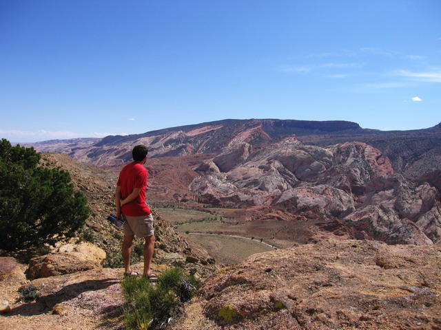
At this point in the trip, we were hoping to cut out nearly 75 miles of driving by taking the Bullfrog Ferry across Lake Powell / Glen Canyon.  It would also be the first ferry trip for Big Red, our truck.  Unfortunately, it was not to be.  Due to mechanical problems AND personnel problems, the ferry was not running, and we had to drive around Lake Powell.  Ick.  Anyhow, I had recalled, from my previous trip, that the drive up Burr Trail was some of the most stunning scenery I had ever seen in the desert Southwest.  Thank the maker for plate tectonics!  As the centerpiece of Capitol Reef National Park, the waterpocket fold is an uplifted area where the earth buckled upwards under pressure, pushing various layers of sedimentary rock ever higher.  Eventually, cracks started to form, and over millions of years, eroded to form the most surreal of landscapes.  The resulting stunning scenery probably makes Capitol Reef National Park my favorite desert park.  Teresa and I entered the park on the Burr Trail which is actually a pretty decent gravel road.  With our high clearance, we did a side trip to the Brimhall Arch overlook which provides stunning views of the waterpocket fold.

As we were kicking back getting ready to dinner, a gentleman drove up the road, which, in this desolate country, is a rare occurrence.  Turned out to be a really nice guy and we spent the evening chatting and having a few drinks (ok… maybe more than a few) with Dick, a realtor from Salt Lake City, and discussed how wonderful it is to be in the world’s most remote places.  He explained to us that the waterpocket fold has a sibling known as the San Rafael swell, just a few hours to the Northeast.  We bid Dick farewell the next morning, while Teresa and I headed off to hike out to Brimhall Arch.  I hiked out to Brimhall Arch on my former driveabout.  The hike is now more difficult than I recall… which, given the occurrence of occasional flash floods, is definitely possible.  Take the scene from my earlier hike (ignoring the former girlfriend), and then compare to the recent scene.

Kinda hard to see, but there seems to be a lot less sediment than before!  I don’t know… maybe I’m just getting older.  Anyhow, I did manage, barely, to get up over that rock, but Teresa wasn’t so lucky.  She waited for me while I wandered up to get a better view of Brimhall Arch.  In addition, Teresa slid down a rock embankment tearing up her brand new REI convertible shorts.  And the best part, we caught it on video!  We’ll definitely put that in a future podcast!

Next, it was on to Capitol Reef’s historic district in Fruita where the park maintains fruit orchards left over from a Mormon Settlement.  Unfortunately, we were too early to catch any ripe fruit, and we were running out of time to meet my parents in Utah, so we headed out of the park.

We didn’t realize it at the time, but we were about to visit more bizarre desert scenery up against the aforementioned San Rafael swell:  Goblin Valley.  The weather here has eroded the rocks into bizarre mushroom or goblin shapes.  Some of them looked like my nose (IE big!)

Our last stop on this jaunt was Moab, UT where we met my parents for some gorgeous desert scenery.  I think Moab area has some of the most impressive scenery in the world.  Moab originally was known for its world class mountain biking.  But after mountain biking there a number of years ago, I would have to disagree.  The biking in Moab is on one of two types of surfaces:  slickrock and sand.  And slickrock is a misnomer because your tires stick to it like glue.  When biking on trails near Atlanta, you have rock, sand, shale, mud, gravel, tree roots, etc… far more challenging in my opinion.  But nonetheless, slickrock is unique in its uniformity, and it is fun to ride on… so long as you don’t fall.  Anyhow, people have discovered that Moab is also a great place for four-wheeling, river rafting, base jumping, etc… It is literally being loved to death.  We found out, when we arrived, that the dispersed BLM camping is disallowed anywhere near Moab.  In other words, due to health reasons from overuse, they’ve had to close off all free camping near Moab.  The BLM has set up a number of campgrounds around the area that are fairly cheap, but many of them were full.

My mom was nursing a bad back, so long hikes were out.  Nonetheless, we did get out and see all the major sites nearby, including Dead Horse State Park, Canyonlands National Park, and Arches National Park.

As you can see, Moab is truly filled with spectacular scenery based on some awesome exposed geology.

Anyhow, arriving in late May, things were very hot in Moab.  Unfortunately, my parents, being on vacation, weren’t in the “get up early” kind of mood.  We arrived at our destinations around 10 or 11am, so by the time we got out, temperatures were above 90 degrees.  We all tired of this rather quickly.  Only being four hours from their house in Edwards, we decided to head for higher elevations and end the Moab trip early.  They agreed, the scenery was outstanding, and they do want to return sometime in a more agreeable season.  Oh well… what’s that quote?  “The best laid plans of mice and men…”

So our final stop, ending our 5 months of travel, was Edwards, Colorado where we would relax for the next month and find our future home.  See former blog entry for details!

Posted in T&A's Big Adventure - Main Blog | Comments Off on Northeast Arizona And Southeast Utah